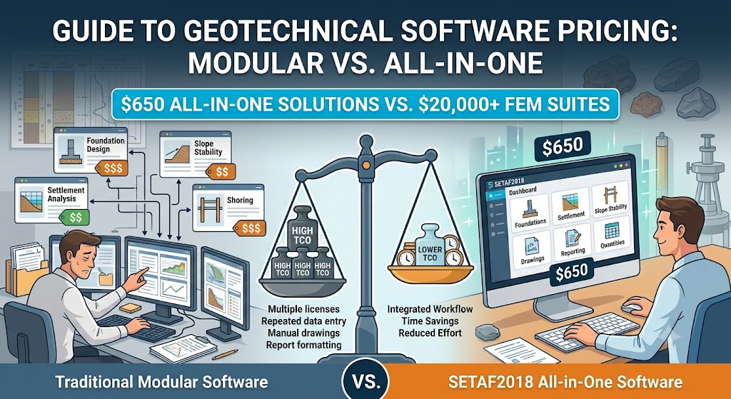
Geotechnical engineering software can cost anywhere from a few hundred dollars for a specialized calculation tool to more than $20,000 per year for advanced 3D finite element analysis platforms. The final price depends on what the software is designed to do, whether tools are sold individually or as part of a complete package, the licensing model, and the level of 2D or 3D numerical analysis required.
But the license price alone does not tell the whole story. A lower-cost module may handle one specific task, while an engineering firm working across foundation design, settlement analysis, excavation support, slope stability, and liquefaction may need to purchase and manage several different programs. Reporting, engineering calculations, project drawings, and quantity takeoff can also require additional tools or manual work, increasing the real cost of the workflow.
This is where pricing models become particularly important. While many geotechnical software providers divide capabilities across separate modules or licensing tiers, SETAF2018 offers an all-in-one geotechnical engineering software solution for $650, bringing multiple analysis, design, drafting, and reporting workflows into a single environment.
So, how much is geotechnical engineering software, and what should you actually expect to get for your budget? In this guide, we’ll compare typical geotechnical software prices, examine what drives the difference between a $650 solution and a $20,000+ engineering suite, and look at why the **total cost of ownership—not just the license price—**matters when choosing software for day-to-day geotechnical engineering projects.
How Much Does Geotechnical Engineering Software Cost?
Geotechnical engineering software typically costs between $300 for individual calculation modules and more than $20,000 for advanced 3D finite element analysis suites. Pricing varies significantly depending on the scope of the software, the complexity of the analysis, whether modules are purchased separately, and the type of license offered.
For engineers and firms, the most important distinction is therefore not simply how much the software costs, but what is included at that price. A specialized module may be sufficient for a single calculation type, while multidisciplinary geotechnical workflows may require either several separate licenses or a broader all-in-one platform.
| Software Category | Typical Price Range | Best Suited For |
| Individual geotechnical modules | $300–$1,000+ | Specific calculations and specialized analysis needs |
| All-in-one analytical software | $650–$3,000+ | Day-to-day geotechnical analysis and design workflows |
| Advanced 2D analysis suites | $3,000–$10,000+ | Specialized numerical analysis and complex engineering projects |
| Advanced 3D FEM suites | $8,000–$20,000+ | Complex nonlinear modeling and advanced soil-structure interaction |
These ranges should be considered general pricing benchmarks rather than fixed costs. Geotechnical software prices can change based on the provider, region, licensing terms, subscription period, number of users, and selected modules or product tiers. As a result, two solutions that appear similar at first glance can have substantially different total costs once the required capabilities and licenses are included. The same comparison applies at the lower end of the range, where free and open-source geotechnical software replaces a licence fee with engineering time.
Geotechnical Engineering Software Price Comparison
The cost of geotechnical engineering software varies considerably depending on its technical scope and licensing structure. Some providers offer individual programs or modules for specific analyses, while others use tiered subscriptions based on modeling capabilities. All-in-one solutions take a different approach by combining multiple engineering workflows under a single license.
The table below provides an estimated price comparison of several widely used geotechnical engineering software solutions:
| Software | Core Functionality | Estimated Price | Pricing Model |
| SETAF2018 | Foundations, settlement, shoring, slope stability, liquefaction, design, reporting & drawings | $650 | All-in-One |
| Rocscience | Specialized slope stability, settlement and pile analysis | $649–$8,899 per program | Module / Program Based |
| Bentley PLAXIS | Advanced FEM soil and structural deformation modeling | $4,450–$20,894 | Tier Based |
| Seequent GeoStudio | Integrated slope stability, groundwater flow and geo-analysis | $3,200–$8,190+ | Tier Based |
| Bentley gINT / OpenGround | Borehole data management, field data logs and subsurface reporting | $2,306–$7,485 | Subscription |
| GEO5 | Modular analytical tools for retaining walls, foundations and slope stability | $300–$800 per individual module | Module Based |
The comparison highlights why the headline price should always be considered alongside the software’s scope. A lower-priced individual module may be cost-effective when an engineer needs only one specialized capability, while firms handling multiple types of geotechnical projects may need several programs or modules to cover their regular workflow.
SETAF2018 follows an all-in-one model, providing multiple geotechnical analysis, design, reporting, and drawing capabilities under a single $650 license rather than selling its primary capabilities module by module. This makes its pricing structure particularly relevant when comparing the combined cost of software required across different stages of routine geotechnical project delivery.
Prices are estimates and may vary by region, license type, subscription terms, and product configuration. Always check the provider’s current pricing before purchasing.
Why Do Geotechnical Software Prices Vary So Much?
The price of geotechnical engineering software is determined by more than the number of analyses a program can perform. Modeling complexity, numerical methods, licensing structure, and the amount of the engineering workflow covered by the software can all have a significant impact on cost. For this reason, two platforms that both support geotechnical analysis may belong to entirely different price categories.
2D vs. 3D Analysis
Software designed primarily for 2D analysis is generally less expensive than platforms built for advanced 3D modeling. Three-dimensional analysis requires more sophisticated modeling environments, greater computational resources, and additional development complexity.
However, not every geotechnical project requires a full 3D numerical model. For routine foundation, settlement, excavation support, or slope stability projects, engineers should consider whether advanced 3D capabilities will actually be used frequently enough to justify the additional software cost.
Analytical Methods vs. Advanced FEM
The underlying analysis method is another major factor in geotechnical software pricing. Analytical and classical soil mechanics approaches are often designed to solve common engineering problems efficiently, while advanced finite element method (FEM) software can model more complex soil behavior, construction stages, and soil-structure interaction.
Advanced FEM capabilities are valuable when project complexity requires them, particularly for nonlinear soil behavior or sophisticated numerical modeling. They also tend to place software in a higher price category. The right choice therefore depends on the type of projects an engineering team regularly handles rather than simply selecting the platform with the most advanced computational capabilities.
Individual Modules vs. All-in-One Software
Geotechnical software companies also structure their products differently. Some platforms divide foundation analysis, settlement, slope stability, retaining structures, and other capabilities into individual programs or modules. This allows engineers to purchase only the tools they need, which can be economical for highly specialized workflows.
The cost equation changes when multiple analysis types are required. Purchasing several modules separately can increase the total software investment and may require engineers to work across different applications. All-in-one geotechnical software instead brings multiple capabilities into a single package, making the total scope included in the license an important part of any price comparison.
Personal, Floating and Enterprise Licensing
The same software can have significantly different prices depending on how the license is used. A personal or single-user license is typically the least expensive option, while floating or network licenses allow software access to be shared across a larger engineering team.
Enterprise licensing can introduce additional costs based on the number of users, offices, support requirements, cloud services, or data management capabilities. When comparing prices, engineering firms should therefore confirm whether the quoted figure represents an individual license, annual subscription, concurrent-user license, or broader enterprise agreement.
Analysis-Only vs. Complete Engineering Workflow
Perhaps the most overlooked pricing factor is how much of the actual project delivery process the software covers. Performing an analysis is only one part of a geotechnical engineer’s workload. Design calculations must be documented, results need to be converted into engineering reports, drawings must be prepared, and quantities may need to be calculated before a project can be delivered.
This creates an important distinction between analysis software and workflow-oriented engineering software. SETAF2018, for example, combines its geotechnical analysis capabilities with design calculations, project drawings, reporting, and quantity takeoff functions rather than focusing exclusively on numerical analysis. Its feature set also includes equation-based reporting and project drawings, extending the workflow beyond the calculation stage.
For engineering firms, this means software value should not be measured only by asking “How many analyses can it perform?” A more complete comparison should also consider how much manual work remains after the analysis is finished. Software that reduces the time required to move from input and calculation to design, documentation, drawings, and final reporting may deliver greater overall value—even when another solution offers more advanced analysis capabilities on paper.
The Hidden Cost of Geotechnical Engineering Software
The license price is only one part of the real cost of geotechnical engineering software. Engineering firms should also consider the time spent moving between programs, recreating project data, preparing calculations, producing drawings, and assembling final reports. A software package that appears inexpensive at the point of purchase can become significantly more costly when these operational requirements are added to the equation.
This is where Total Cost of Ownership (TCO) becomes a more useful metric than the license fee alone. When evaluating geotechnical software, firms should consider costs associated with:
- Multiple software licenses: Different project requirements may force firms to maintain several specialized software licenses simultaneously.
- Separate modules: A low entry price can increase quickly when foundation, settlement, shoring, slope stability, or other capabilities must be purchased separately.
- Repeated data entry: Moving between independent programs may require engineers to recreate soil profiles, geometry, loads, and other project information.
- Manual calculation workflows: Additional calculations performed outside the main software environment increase engineering hours and create more opportunities for workflow inefficiencies.
- Manual report preparation: Analysis results often need to be transferred into separate documents before they can become client-ready engineering reports.
- Drawing and detailing time: When drawings are not generated as part of the engineering workflow, additional time must be allocated to preparing project details and technical outputs.
- Training costs: Maintaining several specialized tools means engineers may need to learn and remain proficient in multiple software environments.
- Software switching between project stages: Moving a project from analysis to design, documentation, and reporting across different applications can add friction to every project.
For a geotechnical engineering office completing dozens of projects each year, even small workflow inefficiencies can accumulate into hundreds of engineering hours. The real question is therefore not simply “How much does the software license cost?” but “How much does it cost to complete a project using this software?”
This is where an all-in-one platform such as SETAF2018 can offer a different value proposition. By bringing geotechnical analysis, design calculations, project drawings, reporting, and quantity takeoff into a broader project workflow, the potential saving extends beyond the $650 license price itself. SETAF2018’s documentation, for example, includes automated engineering drawings and sections alongside quantity takeoff and technical reporting capabilities.
Ultimately, the biggest saving may not be the price of the software—it may be the engineering hours saved across dozens of projects. For firms evaluating geotechnical software on price and performance, Total Cost of Ownership provides a more realistic measure of value than comparing license fees alone.
Is Modular Geotechnical Software Actually Cheaper?
Modular pricing can be cost-effective when an engineer needs software for only one specific type of analysis. A $500 module may initially appear cheaper than a $650 all-in-one platform, particularly for a specialist who rarely works outside a narrow project scope. In these cases, paying only for the required functionality can make financial sense.
The calculation changes, however, when a geotechnical engineering office handles a broader range of projects. If separate tools or modules are needed for foundation analysis, settlement, excavation support, and slope stability, the combined software cost can increase quickly.
Consider a simplified example:
| Software Requirement | Example Cost |
| Module A – Foundation Analysis | $500 |
| Module B – Settlement Analysis | $700 |
| Module C – Excavation Support | $800 |
| Module D – Slope Stability | $600 |
| Total Modular Cost | $2,600 |
| Example All-in-One Software | $650 |
The module prices above are hypothetical and are intended only to illustrate how modular pricing can accumulate. They do not represent the pricing of any specific software provider.
In this scenario, the question is no longer whether an individual module is cheaper. It is whether the engineering team needs one specialized capability or a combination of tools across its regular project workload.
There is also an operational dimension to consider. Even when purchasing separate modules remains financially reasonable, engineers may still need to transfer project information between tools, manage separate files, and combine outputs during reporting and project delivery. An all-in-one environment can reduce some of this fragmentation by keeping multiple geotechnical workflows within the same software ecosystem.
This does not mean modular software is inherently more expensive or less valuable. Specialized platforms can be the better choice when a firm needs deep capabilities in a limited area. However, for geotechnical offices regularly working across multiple disciplines, comparing the price of one module against one all-in-one license can be misleading. The more meaningful comparison is the combined cost of all required capabilities—and the engineering time needed to use them together.
SETAF2018: All-in-One Geotechnical Engineering Software for $650
One license. Multiple geotechnical workflows. No module-by-module purchasing.
SETAF2018 takes an all-in-one approach to geotechnical engineering software. For $650, engineers gain access to a broad set of tools covering foundations, settlement, excavation support systems, slope stability, liquefaction, and ground improvement, alongside design, reporting, drawing, and quantity takeoff capabilities.
The objective is not to replace every specialized numerical modeling platform. Instead, SETAF2018 is designed to bring many of the workflows encountered in day-to-day geotechnical engineering practice into a single software environment—from initial analysis and engineering calculations to project documentation and deliverables.
Foundation Analysis
SETAF2018 supports the analysis and design of shallow and deep foundation systems, including raft, isolated, and strip footings, as well as pile and micropile foundations. Engineers can perform settlement and bearing capacity analyses while working with different foundation and ground improvement configurations within the same project environment.
This allows foundation engineering workflows to extend beyond a single calculation, connecting soil data and foundation modeling with the analyses required to evaluate engineering performance.
Excavation Support and Shoring Design
Excavation support is another major part of the platform. SETAF2018 supports the modeling, analysis, design, and drafting of systems including bored pile walls, anchored excavation support structures, soil-nailed systems, and reinforced concrete retaining walls.
The software uses engineering approaches suited to practical excavation support design, including the dependent pressures method, alongside relevant earth pressure and support calculations. This positions it as a practical tool for engineering offices that regularly design shoring and excavation support systems rather than requiring a separate program for this stage of the project.
Slope Stability Analysis
SETAF2018 includes slope and embankment stability analysis based on limit equilibrium methods. Engineers can evaluate potential slip surfaces and calculate factors of safety as part of the broader geotechnical model.
For firms handling foundations, excavation support, and slope-related projects, having slope stability capabilities within the same software package reduces the need to purchase a separate application solely for routine stability assessments.
Liquefaction Analysis
Liquefaction assessment is also integrated into the SETAF2018 workflow. The software supports liquefaction calculations and related evaluations, allowing engineers to incorporate this analysis into projects where seismic soil behavior must be considered.
Rather than treating liquefaction as a completely separate software requirement, it becomes another available capability within the same geotechnical engineering environment.
Ground Improvement
SETAF2018 extends into ground improvement applications, including deep mixing and jet grouting systems. The software also supports foundation systems involving rigid columns and other improvement configurations, enabling engineers to evaluate projects where foundation performance and soil improvement need to be considered together.
This broader scope is particularly relevant for engineering firms whose projects cannot always be separated neatly into a single category such as “foundation analysis” or “settlement analysis.”
Engineering Reports, Drawings and Quantity Takeoff
One of the most important differences in evaluating SETAF2018 is what happens after the analysis is complete. The platform is not limited to producing numerical results. It also supports technical reporting, engineering tables and charts, automated project drawings and sections, and quantity takeoff outputs.
This changes the value proposition of the $650 price point. The comparison is not simply between SETAF2018 and another calculation module; it is between different approaches to completing a geotechnical project. By connecting analysis and design with the outputs required for project delivery, the software can reduce the manual work that typically takes place between calculation and final documentation.
In that sense, SETAF2018 is positioned as more than geotechnical analysis software—it is a project delivery tool. For engineering offices that regularly work across multiple geotechnical disciplines, the combination of an all-in-one license and an integrated workflow can provide value not only through lower software costs, but also through the time saved in delivering each project.
How SETAF2018 Can Reduce the Real Cost of Geotechnical Projects
Reducing software costs is not simply about choosing the license with the lowest price. For geotechnical engineering firms, a significant part of the real cost comes from the engineering hours required to move a project from initial modeling to final delivery. Every repeated data entry, manual calculation, software transition, drawing, and report adds time to the project.
SETAF2018 approaches this problem by bringing multiple stages of the geotechnical workflow into a single environment. The potential financial benefit therefore extends beyond its $650 all-in-one license.
- Less Software Switching: Engineers can work across foundations, settlement, excavation support, slope stability, liquefaction, and other supported workflows without relying on a separate application for every project stage. This can reduce the friction created by constantly moving between different software environments.
- Less Repetitive Data Entry: Keeping multiple engineering processes within the same project environment can reduce the need to repeatedly recreate project information. For firms managing many projects simultaneously, even small reductions in repetitive work can translate into meaningful time savings over the course of a year.
- Faster Engineering Calculations: SETAF2018 is oriented toward practical, day-to-day geotechnical engineering workflows. Instead of requiring advanced numerical modeling for every problem, engineers can apply established engineering methods to routine foundation, settlement, excavation support, and stability calculations where appropriate.
- Automated Drawings and Reports: Analysis is rarely the final deliverable. SETAF2018 can extend the workflow into technical reports, engineering tables and charts, project drawings, sections, and quantity takeoff outputs, reducing some of the manual work required after calculations are complete.
- Lower Software Licensing Costs: Rather than purchasing core capabilities module by module, SETAF2018 provides its supported geotechnical workflows through an all-in-one model. For firms that regularly need several types of analysis, the relevant comparison is therefore not the price of one specialized module, but the combined cost of maintaining the software capabilities required across the entire project portfolio.
The impact becomes more significant as project volume increases. Saving an hour on a single project may seem relatively minor. Saving several hours across dozens—or hundreds—of projects can directly affect engineering capacity, project turnaround times, and ultimately profitability.
The biggest saving may not be the $650 license. It may be the engineering hours saved across dozens of projects.
For geotechnical engineering firms, this is where the economics of an all-in-one platform become most relevant. The value of SETAF2018 is not based solely on being less expensive to purchase, but on the possibility of completing more of the engineering workflow with fewer software transitions, less repetitive work, and less time spent turning calculations into deliverable project outputs.
When Does It Make Sense to Pay More for Geotechnical Software?
More expensive geotechnical software is not necessarily overpriced. In many cases, the higher cost reflects advanced numerical capabilities developed for projects where conventional analytical methods are not sufficient. The right question is therefore not whether a $20,000 platform is “better” than a $650 solution, but whether your projects actually require the additional capabilities you are paying for.
Advanced finite element method (FEM) software such as PLAXIS or MIDAS may be the appropriate choice when projects involve:
- Complex soil-structure interaction that requires detailed numerical representation of how structures and surrounding soils influence each other.
- Nonlinear soil behavior where simplified or linear engineering models cannot adequately represent expected ground response.
- Advanced staged construction requiring engineers to model excavation, loading, support installation, or other construction sequences step by step.
- Highly complex 3D models where two-dimensional analysis or simplified three-dimensional representations cannot capture critical project behavior.
- Research and specialist numerical modeling where detailed constitutive models, sensitivity studies, or advanced simulations are central to the engineering objective.
These capabilities can justify a substantially higher software investment for specialist consultants, research teams, and engineering firms regularly working on complex infrastructure or technically demanding projects. In these cases, choosing software based primarily on license price could be a false economy.
SETAF2018 is not positioned as a replacement for every advanced FEM use case. Its strength lies in a different part of the geotechnical engineering market: practical engineering workflows where foundations, settlement, excavation support, slope stability, liquefaction, design, and project documentation need to be completed efficiently. The available comparison data similarly distinguishes SETAF2018’s suitability for daily project practice and rapid preliminary design from the more advanced FEM and nonlinear modeling capabilities available in platforms such as PLAXIS and MIDAS.
For the large volume of routine geotechnical engineering projects, however, paying for advanced numerical capabilities that are rarely used may not always provide the best return on investment. If most of a firm’s workload can be completed using established engineering methods, the more relevant factors may be how quickly analyses can be performed, how many project workflows are covered, and how efficiently calculations can be converted into drawings and reports.
Ultimately, the best-value geotechnical software is not automatically the cheapest or the most technically advanced. It is the software whose capabilities most closely match the projects an engineering team actually delivers. For firms that occasionally require advanced FEM but primarily handle routine geotechnical design work, this may even mean using an all-in-one platform such as SETAF2018 for everyday project delivery while reserving specialized numerical software for the smaller number of projects where its advanced capabilities are genuinely necessary.
How to Choose Geotechnical Software Based on Price and Value
Choosing geotechnical engineering software based on price alone can lead to either overpaying for capabilities you rarely use or saving on the license while creating additional costs elsewhere in the workflow. The better approach is to compare each platform against the type and volume of projects your engineering team actually handles. Where that workload is mainly shallow, raft and pile design, the capability checklist is set out in the guide to foundation design software.
Before purchasing or renewing geotechnical software, consider the following questions:
- What analyses do you perform regularly? Start with your actual project workload. If most projects involve foundations, settlement, excavation support, slope stability, or ground improvement, look at how many of these workflows the software covers without requiring additional products.
- Do you need advanced FEM? Advanced FEM software may be necessary when your projects require highly complex geometries, advanced constitutive material models, or specialized numerical simulations that go beyond conventional geotechnical design workflows. If these requirements are uncommon in your typical projects, consider whether the additional software cost is justified by how often you will actually use them.
- Are modules sold separately? A low starting price does not necessarily represent the final software cost. Determine which modules are included, which must be purchased separately, and how much it would cost to assemble the complete toolset your team requires.
- How many licenses will your office need? Software costs can increase considerably when multiple engineers require access. Compare personal, floating, network, and enterprise licensing options based on how your team actually works.
- Does the software generate engineering reports? Consider what happens after the calculation is complete. If results must be manually transferred into separate documents and formatted into technical reports, those additional engineering hours should be included in the cost evaluation.
- Can it generate drawings? Automated project drawings and sections can reduce the gap between engineering analysis and final project delivery. For firms producing drawings regularly, this capability may have greater financial value than a small difference in license price.
- Does it support design as well as analysis? Analysis identifies how a system is expected to behave, but engineering projects often require additional design calculations before they can be delivered. Software that connects analysis and design can help create a more continuous workflow.
- How much engineering time can it save? Estimate the hours spent on repetitive data entry, moving between applications, manual calculations, drawings, and report preparation. Even modest time savings per project can become significant when multiplied across an entire year’s workload.
- What is the total annual software cost? Include more than the advertised entry price. Account for required modules, subscriptions, additional licenses, upgrades, support, and any complementary software needed to complete the workflow.
- What is the total cost of ownership? Finally, combine the direct cost of purchasing the software with the indirect cost of using it. Licensing expenses, engineering hours, training, workflow fragmentation, and manual project delivery tasks all contribute to the true cost of a software platform.
Ultimately, the best-value geotechnical engineering software is the solution that provides the right level of technical capability at the lowest practical cost of completing your projects. For some firms, that may justify investing in an advanced FEM suite. For others, an all-in-one platform that covers frequently used engineering workflows while reducing manual work and additional software requirements may deliver a stronger return on investment.
Is $650 a Good Price for Geotechnical Engineering Software?
For an individual calculation tool, $650 may not necessarily be inexpensive. But the value equation changes when that price includes multiple geotechnical workflows in a single environment rather than access to a single specialized module.
SETAF2018’s $650 all-in-one license covers a broad range of day-to-day geotechnical engineering tasks, including foundation analysis, bearing capacity, immediate and consolidation settlement, excavation support and shoring design, slope stability, liquefaction assessment, and ground improvement applications. The platform also extends beyond analysis into design calculations, technical reporting, project drawings, and quantity takeoff.
This makes the price particularly relevant for firms that would otherwise need multiple specialized tools to cover their regular workload. Instead of asking whether $650 is inexpensive in isolation, the more useful question is how many software licenses, modules, and engineering hours the platform can potentially replace or reduce.
For consultants and geotechnical engineering offices that regularly work across foundations, excavation support, settlement, and slope stability, SETAF2018’s $650 all-in-one model can significantly reduce the cost of maintaining multiple specialized software licenses. The potential return becomes even greater when the time saved on calculations, drawings, reporting, and moving between separate software environments is considered.
That does not make SETAF2018 the right solution for every project. Firms that regularly perform highly complex 3D or nonlinear FEM analyses may still require specialized numerical modeling platforms. But for engineers looking for broad practical capabilities without paying separately for multiple modules, $650 represents a strong price-to-capability ratio.
Ultimately, the value is not simply in paying less for software. It is in having more of the geotechnical project workflow available under one license.
Looking for an all-in-one alternative to module-by-module geotechnical software? Explore SETAF2018 and see how its $650 license can fit your engineering workflow.
Frequently Asked Questions About Geotechnical Software Pricing
How much is geotechnical engineering software?
Geotechnical engineering software can cost anywhere from approximately $300 for individual modules to more than $20,000 for advanced 3D FEM platforms. The final price depends on the analysis capabilities, 2D or 3D modeling requirements, licensing structure, and whether features are purchased separately or included in an all-in-one package. When comparing prices, engineers should consider both the license fee and the total cost of completing their typical project workflow.
Why is geotechnical engineering software so expensive?
Geotechnical software often requires specialized engineering algorithms, numerical modeling capabilities, continuous development, technical support, and compliance with relevant engineering methods and standards. Advanced platforms may also include nonlinear material models, complex soil-structure interaction, staged construction, and sophisticated 3D FEM capabilities. However, higher prices are not always necessary for every engineering office, particularly when most projects can be completed using established analytical methods and practical design workflows.
What is the cheapest geotechnical engineering software?
There is no single cheapest option for every use case because some providers sell individual modules while others offer broader software packages. A specialized module costing a few hundred dollars may be the least expensive choice if you only need one type of calculation, but purchasing multiple modules can quickly increase the total cost. The cheapest software is therefore not necessarily the best-value software; the better comparison is how much it costs to obtain all the capabilities your projects regularly require.
Is geotechnical software sold as a subscription or perpetual license?
Both licensing models are used in the geotechnical software market. Some providers offer annual subscriptions, while others provide perpetual licenses or different options based on users, modules, and product tiers. Before purchasing, firms should check not only the initial price but also renewal fees, upgrade costs, maintenance, technical support, and restrictions on how many engineers can access the software.
Is it cheaper to buy individual geotechnical software modules?
It can be cheaper when you consistently need only one specialized capability. However, an engineering firm that requires separate tools for foundations, settlement, excavation support, slope stability, and other analyses may find that module-by-module pricing becomes more expensive over time. The total cost should also account for the operational impact of maintaining and working across multiple software environments.
How much does geotechnical FEM software cost?
Advanced geotechnical FEM software can range from several thousand dollars to $20,000 or more, depending on whether the platform supports 2D or 3D modeling, nonlinear soil behavior, staged construction, and advanced soil-structure interaction. These capabilities can justify the higher investment for complex infrastructure and specialist numerical modeling projects. Firms primarily handling routine geotechnical design should evaluate how frequently they actually require advanced FEM before making the additional investment.
What should a small geotechnical engineering firm budget for software?
The appropriate budget depends on project scope rather than company size alone. A small specialist consultancy may need only one or two focused tools, while another firm working across foundations, settlement, shoring, and slope stability may require a broader software stack. Small firms should calculate the combined cost of licenses, modules, renewals, reporting and drawing tools, and the engineering hours spent moving between them before setting a realistic software budget.
Can one geotechnical software handle foundations, shoring and slope stability?
Yes, some all-in-one geotechnical engineering platforms are designed to cover multiple project workflows under a single license. SETAF2018, for example, supports foundation and settlement analysis, excavation support systems, slope stability, liquefaction, and ground improvement, while also providing capabilities for engineering calculations, reporting, drawings, and quantity takeoff. For firms regularly working across these areas, an integrated platform can reduce the need to maintain separate software for each stage of routine geotechnical project delivery.