Release Notes
See what changed in each release. Click a version for the full details.
📌 Localization and International Standards
- US Customary Units: Integration of the US customary unit system has been completed.
- International Concrete and Reinforcement Standards: Full support has been provided for concrete and reinforcement standards in many countries, particularly the USA and Canada.
- Dynamic Reporting Integration: All general and local calculation reports are now fully compatible with US customary units.
- Standards-Compliant Project Drawings: Project drawings are now automatically generated according to the selected reinforcement standard and regional units.
🤖 Geotechnical AI Agent Integration (SETAF AI Geotechnical Assistant)
The AI-powered SETAF AI Geotechnical Assistant has been integrated into the software. A Terminal and Agent Interface have been added to the main screen so that the agent can actively control the software and carry out analysis processes.
🌟 Key Capabilities of the Geotechnical AI Agent:
The SETAF AI Geotechnical Assistant can produce a complete end-to-end project based on soil investigation reports (.pdf, .doc), foundation/site plan drawings (.dwg, .dxf, .png, .jpg), and user instructions (prompts).
- End-to-End Automation, from Report to Report: Reads the soil investigation report, builds the soil model, defines foundations, performs bearing capacity, settlement and liquefaction analyses, evaluates the results and generates the geotechnical report. Automatically proceeds to subsequent steps in multi-step tasks.
- Converting Soil Investigation Reports into Models: Extracts borehole logs, laboratory/field test results, groundwater levels, SPT and pressuremeter (MPM) values. Defines materials, creates boreholes and validates data entry.
- Intelligent Foundation Analysis and Design Optimization: Performs bearing capacity, settlement, consolidation, liquefaction and DSM/rigid-column analyses for shallow/deep foundations. When criteria are not met, automatically revises foundation dimensions, elevation, type or element layout and iteratively reruns the analyses.
- Automatic Geotechnical Report Preparation: Creates excavation, site or general geotechnical report templates; adds sections, writes explanatory engineering text, inserts analysis tables and charts, and formats visuals.
- Foundation Geometry from Drawings and Images: Detects foundation outlines, openings and grid axes from site and foundation plans in DWG, DXF, PNG or JPG format. Determines drawing units, creates separate foundations for multiple blocks and validates their positions.
- Borehole Idealization Using Engineering Judgment: Groups boreholes by location, layer profile and similarity of material parameters; filters outliers to create representative idealized boreholes and stratigraphy.
- Comprehensive Soil Material Management: Provides parameter management including unit weight, shear strength and deformation moduli; built-in calculators for DSM and jet grouting; and selection of values from engineering ranges for missing parameters.
- Detailed Borehole, Layer and Foundation Model Management: Fully models borehole coordinates, SPT/MPM profiles, layer drainage and water pressure distributions, rectangular/polygonal foundations, load/moment components and deep foundation/pile group settings.
- Unit and Standards Compatibility (Metric and US Customary): Fully accommodates project, report or preferred unit systems (kPa, kN/m³ or psf, pcf, ft) and standards; automatically converts all numerical values.
- Safe, Transparent and Flexible Operation: Performs all operations in real time through the interface, automatically rolls back on errors, maintains detailed logs and accepts chained commands in natural language (Turkish/English) or through the Terminal.
🛠️ Fixes
- Piled Foundation PDF Report Fix: Fixed an error when generating a PDF report if the pile tip extended below the defined depth of the borehole. A warning now appears before analysis and reporting when the pile tip is below the soil profile. The warning displays the pile tip elevation and the bottom elevation of the soil profile. To proceed, the user must shorten the pile or extend the borehole depth below the pile tip. Existing project files (.STF) open unchanged; projects with pile tips within the soil profile are unaffected.
Seismic Effects in Slope Stability Analyses
A pseudostatic analysis feature accounting for seismic effects in slope stability analyses has been added to SETAF2018.
With this feature, users can define horizontal and vertical seismic effects and calculate the seismic factor of safety using the Fellenius and Simplified Bishop methods.
New Features
- Seismic analysis has been added to slope stability analyses.
- Seismic effects are accounted for through horizontal and vertical pseudostatic forces acting on each slice.
- Seismic forces are resolved relative to the slice base direction and incorporated into the analysis equations.
- The feature can be used for both single slip-circle analysis and optimized multiple slip-circle searches.
- The Fellenius and Simplified Bishop methods are now compatible with the seismic analysis option.
Options for Defining Seismic Effects
Users can define seismic effects using three approaches:
1. User-Defined Seismic Coefficients
With this option, users can directly enter:
- horizontal seismic coefficient,
- vertical seismic coefficient
to perform the analysis.
This method is suitable for special project conditions or where user-specified pseudostatic coefficients are required.
2. Eurocode Approach
With the Eurocode option, seismic effects are calculated using:
- reference ground acceleration,
- importance factor,
- soil factor,
- vertical/horizontal acceleration ratio
as parameters.
This option enables a more systematic approach to slope stability analyses in Eurocode-based projects.
3. TBDY 2018 Approach
With the TBDY 2018 option, seismic effects are determined considering:
- short-period design spectral acceleration coefficient,
- topographic amplification factor,
- slice weight.
These parameters are taken into account.
This option was developed for projects requiring seismic slope stability assessment under the 2018 Turkish Building Earthquake Code.
Interface Updates
- New input fields have been added to the slope analysis settings screen for defining seismic effects.
- When seismic effects are enabled, the relevant parameter fields automatically appear according to the selected method.
- The user interface has been reorganized to make entry of seismic analysis parameters easier and more controlled.
DXF Terrain Import Enhancement
This release also adds terrain surface import from DXF files to speed up slope model creation.
Users can import terrain surfaces created in AutoCAD into the program in DXF format. The program reads the relevant lines in the DXF file, allowing terrain geometry to be defined in the model more quickly.
This feature makes model creation more practical, particularly for long or complex terrain profiles.
Applications
This update provides significant convenience particularly for:
- seismic slope stability analysis,
- hillside and landslide stability assessment,
- excavation slopes,
- embankment slopes,
- code-based geotechnical assessments
in these applications.
With this update, SETAF2018 enables more comprehensive, flexible and code-compliant evaluation of seismic effects in slope stability analyses.
Reporting and Usability Improvements
This update improves SETAF2018's reporting infrastructure and certain default behaviors.
Liquefaction Local Report Updates
- Turkish and English translations in the local liquefaction report have been completed.
- Language consistency of table headings in English reports has been improved.
- Fixed some tables not fitting on the page when the Boulanger–Idriss method and rigid-column effect were selected.
- Report tables now have better layouts, especially in English output.
Report Improvement for NP Soils
- The display of values in reports has been improved for soils entered with plasticity index Ip = 0.
- In this case, NP is appropriately displayed instead of Ip, wL, wP and wS values in reports.
- This change has been applied to both the local liquefaction report and the general report.
Fix for Default Foundation Dimensions
- Fixed a potential error when proceeding with the default foundation dimensions shown at startup.
- Lx and Ly values are now handled correctly when analyses are performed without changing the default foundation dimensions.
Analysis Summary Performance Improvement
- Subgrade reaction modulus analysis is no longer selected by default in the analysis summary options.
- This prevents unnecessarily long summary report generation times.
- Users can manually select the subgrade reaction modulus analysis and include it in the report if needed.
This update makes report language consistency, table layouts, NP soil representations and analysis summary performance more reliable.
New Features
SETAF2018 – Liquefaction Analysis Enhancements
In this release, the liquefaction module has been extensively enhanced. Liquefaction susceptibility assessment and triggering analyses have been separated, creating a more realistic workflow aligned with engineering practice.
New: Liquefaction Susceptibility Assessment
Before liquefaction analyses, soils are now automatically evaluated for liquefaction susceptibility according to the selected method.
TBDY 2018 Susceptibility Criteria
When TBDY 2018 is selected, the program:
- Soil classification
- Fines content (FC)
- Clay content (C)
- Plasticity characteristics
- Corrected SPT blow count (N₁,₆₀)
uses these criteria to evaluate liquefaction susceptibility at each depth.
The result at each depth is classified as:
- Susceptible to Liquefaction
- Not Susceptible to Liquefaction
accordingly.
New: Boulanger–Idriss (2006) Method
The Boulanger–Idriss (2006) approach has been added to the liquefaction module.
Under this method, soils are first classified by behavioral type:
- Sand-like
- Clay-like
soils.
Classification is primarily based on:
- Plasticity Index (PI)
- Liquid Limit (LL)
- Fines content (FC)
criteria.
The applicable behavior type at each depth is displayed in reports and result tables.
New: Triggering Analysis for Clay-Like Soils
In previous versions, liquefaction triggering calculations were applied only to SPT-based sand-like soils.
With this release:
- for soils classified as clay-like,
- based on undrained shear strength (Su / Cu),
- using the Boulanger–Idriss (2006) approach,
triggering analyses can be performed.
Thus, within the same soil profile:
- Sand-like layers
- Clay-like layers
can be evaluated in a single analysis.
Enhanced Triggering Analysis Workflow
The program now follows different workflows depending on the selected method.
TBDY 2018
The program first performs a liquefaction susceptibility assessment.
By default:
- Only depths identified as susceptible are included in triggering analysis.
Optionally:
If the "Perform Triggering Analysis at All Depths" option is selected:
- Regardless of the susceptibility result,
- the factor of safety (FS) can be calculated at all depths.
Boulanger–Idriss (2006)
All depths are evaluated with this method.
- SPT-based triggering analysis is applied to sand-like soils.
- Su (Cu)-based triggering analysis is applied to clay-like soils.
The factor of safety (FS) is calculated at each depth.
Enhanced Results Tables
Liquefaction results tables have been reorganized.
The new tables clearly show:
- Susceptibility assessment
- Sand-like / Clay-like classification
- Method used
- Calculated factor of safety (FS)
- Check result
clearly.
Enhanced Reporting
Liquefaction reports have been substantially expanded.
Reports now provide:
- Method used
- Filtering criteria applied
- Susceptibility assessment at each depth
- Sand-like / Clay-like classifications
- Triggering analysis results
- Factors of safety
- Check results
in detail.
Reports can also be generated for profiles with no liquefaction susceptibility, ensuring that the assessment process is fully documented.
Engineering Benefits
These enhancements provide the following benefits:
- Liquefaction susceptibility and triggering analysis are separated.
- Fine-grained soil behavior is assessed more realistically.
- Sand-like and clay-like soils can be analyzed together within the same profile.
- Users can choose between the TBDY 2018 and Boulanger–Idriss (2006) approaches.
- Traceability and reportability of results have been significantly improved.
Trial Version Activation
To test the software, you can activate your trial license by following the steps below.
1. Software Installation
- Download the "Setaf Setup" file to your computer by clicking the "Download" menu in the top menu.
- Complete the installation by running the downloaded setup file.
2. Trial License Request
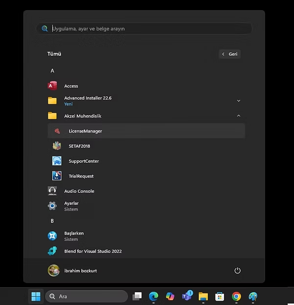
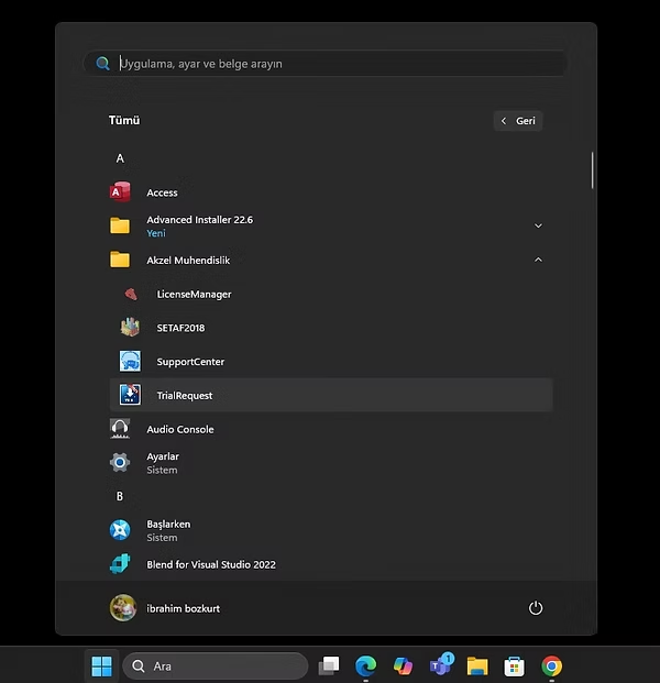
- After installation is complete, open the Start Menu > Akzel Mühendislik folder on your computer.
- Run the TrialRequest program.
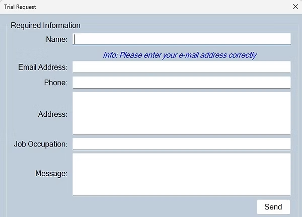
- Fill in all information completely and accurately in the form that opens.
- After filling out the form, click the "Send" button.
- If you see the message "Your request has been forwarded to the technical team," the process has been completed successfully.
3. Software Activation
- After evaluating your application, the technical team will send your User ID and Activation Key to your email address.
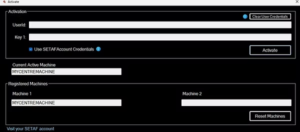
- Open the LicenseManager program located in the same folder.
- Uncheck the "Use SETAFAccount Credentials" option.
- Enter the User ID and Activation Key sent to you into the respective fields.
- You can activate the software by pressing the "Activate" button.